Christmas Day Storm to produce Heavy Snow; Ice and Blizzard conditions for some

Computer models paint an increasingly wintry picture for Christmas day.
A serious cold front is expected to move east on Christmas eve, bringing a swathe of much colder than average temperatures to much of the mid west and North East. This will produce sub zero day time heights for a swathe from Chicago, through the lakes and into New England.
The following chart for Christmas Day at 6pm shows those significantly colder than average temperatures across this area. Of course, this cold front will also produce a lot of precipitation & a risk of snow showers over the lakes, lake effect snow. This is discussed below.

Given the low pressure associated with this Arctic Blast, there would be a high risk of significant lake effect snow for areas on the south eastern side of all the Great Lakes.
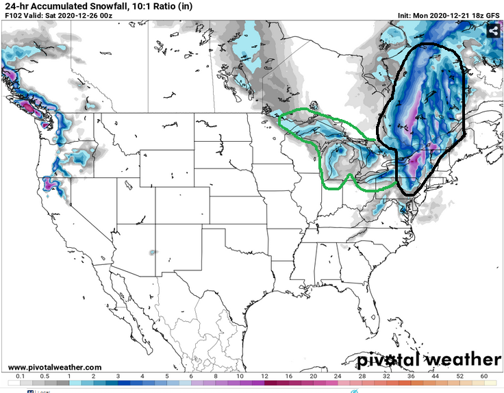
Some 5-10″ is possible here locally on Christmas Day and Boxing Day, with some strong winds producing a risk of drifting in places. Up to 12″ is possible from Lake Effect on Christmas day locally around the Lakes.
There will also be a significant frontal system in the east on Christmas Eve (24th) and Christmas Day. This will produce a mixture of rain, sleet and snow for more coastal districts, however inland some significant snowfall is possible.
4-6″ is possible for parts of West Virginia, PA, and perhaps 6-10″ through northern New York State and into New England. Coastal strips will remain snow-free and likely experience rain. Come inland though, and expect snow.
The snowfall front as it passes will be very intense and only last an hour or two, so whilst the overall snowfall totals wont be massive, roads could become nasty fairly quickly and fall at rates which may overwhelm ploughing. And don’t forget the serious cold which will be accompanying this period away from the immediate east coast.
The following map shows where snow accumulation is expected on Christmas day. Note the area circled in black which is likely to see the heavy snow front. The area in green is at risk of significant lake effect snows. Enjoy, but stay safe!
