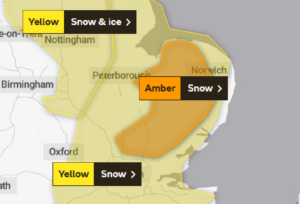
Met Office issue “Amber” warning as 4 Inches of Snow expected in South Tomorrow
An Amber snow warning has been issued for parts of Southern England (UK) for tomorrow, the 15th of January 2021. Up to 10cm (4″) may fall locally across inland East Anglia, producing the risk of some travel disruption. The snowfall is expected to coincide with rushour producing the risk of some road and travel impacts during this time.

The Met Office says:
A band of heavy snow is likely to bring disruption as it moves eastwards on Saturday.
What to expect
- Travel delays on roads are likely, stranding some vehicles and passengers
- Some delays and cancellations to rail and air travel are likely
- There is a good chance that some rural communities could become cut off
- Power cuts are likely and other services, such as mobile phone coverage, may be affected
Our forecast indicates much the same, in that a band of precipitation is likely to bump into the cold air and produce a mixture of heavy rain, sleet and heavy snow tomorrow (Saturday) morning.
There is likely to be a mixture of rain, sleet & snow for central areas including the East Midlands, Yorkshire and North East England with most of the snow here being confined to hills. However, some accumulations to lower levels of 2-8cm are possible.
In contrast,, the precipitation across the east (Lincolnshire and East Anglia) is likely to fall as snow to increasingly low levels especially inland. Here, 5-10cm is likely widely.
For London and the far south east, a wintry mix is possible to lower levels giving patchy accumulations of 1-4cm locally. Significant accumulations will mostly be confined to hills in this area.
The following map from Meteociel highlights where snowfall is more likely to fall and accumulate tomorrow.
