Winter Weather Forecast: Double the Average Snow for DMV
Recently we saw that the Farmer’s Almanac Winter Forecast was predicting a snowier than average one, with “Teeth Chattering” conditions for the Mid West, and a strong signal for snowy conditions through the Great Lakes and east. The signal also points for less cold conditions in the upper north west, Pacific North West. These are typical El Nino winter conditions. Our winter forecast, at severe weather updates 2018, can be accessed right here it also points towards a chilly winter in the north east, compared to average, with the best of the weather in the north west.
NBC Washington, news release:
Recently information courtesy of NBC Washington paints a bleak picture for citizens of Washington, with double the average snowfall predicted. There are 3 main factors that are fueling the forecast of cold, snowy conditions this winter.
- El Nino (Warm pacific temperatures), allows a strong polar jet stream to affect eastern states, increasing the frequency of a) cold shots and b) Noreasters.
- Very low solar activity. The sun goes through what we call “cycles” of periods of high and low frequency of sunspots. This year we are at “minimum”, so the sun really is asleep. This will help promote abnormalities in the northern hemisphere jet stream making it colder in the states, by promoting “jet stream wobbles”, – as funny as it might sound.
- Warm North West Pacific, warm sea surface temperatures in the North Pacific help promote high pressure in the Pacific North West, around Alaska, Oregon and Washington *State*, this in turn keeps these areas less cold and snowy, but helps feed cold air into central and eastern parts of the United States.
You can read more about the NBC Washington Winter Outlook Right Here, and below is their winter snowfall totals forecast for the Washington, Maryland and nearby areas:

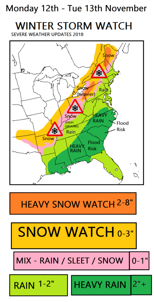
Uncertainty, you can’t be 100%: Long range forecasts are never 100% correct, and are prone to what we call “low forecast confidence”, since they cover a range of time that is beyond the conventional meteorological forecast time. We have pretty cold air over us now, with a significant storm system which will dump some snow to central eastern areas in the next 24 hours.
This is our Winter storm watch for the next 24 hours:

However it will become slightly less cold this during Thursday / Friday of this week, with temperature anomalies waning.
But by the weekend the cold air will be back for most states with a vengeance, and with it the risk of snow flurries in the north, especially around the lakes.