Winter 2018-2019 Prognosis & Regional Forecast

Welcome to our brand new site. Thank you for choosing our site for your winter weather information. We value accurate, informative weather information that is realistic about the uncertainties involved in weather forecasting, especially at long range. The atmosphere is a complex system of circulations and interactions, and working out the ramifications of various factors and how they will “interact with each other” to produce weather down the line, say in a few months time, is almost impossible. We are based in Chicago, Illinois and forecast primarily for the United States and Canada. We have a UK based website version known as veryweather.co.uk.
Winter 2018-2019 Prognosis.
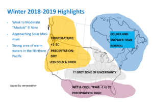
Here are our thoughts for the United States for Winter 2018-2019. The main driving factor of this winter is a moderate El Nino event. I’m sure many of know are aware of what an El Nino is, however for the purpose of those who may not be aware, I will explain. El Nino is a phase of warmer than average sea surface temperatures that develop in the central Pacific Ocean from Peru to Australia and this Oceanic oscillation drives weather, including winter weather, further afield, including the United States and Canada. El Nino winters are typically characterized by a blocking area of high pressure over the north west of the United States which fuels drier and “less cold” weather for the North West. However we are talking relative here, so even if “less cold” weather occurs, it will still be very cold as we are comparing it to average. It’s like saying it will be “less hot” compared to average in Texas in the summer. Still hot, but perhaps not as severely so. The same can be said for snowfall and precipitation. So when we talk of “below average” snowfall, don’t automatically think “no or minimal snowfall”, of course that wont happen for northern states, but think of it as an indication as to how things may be compared to average. Even a significantly less snowy season compared to average in Montana would host a decent amount of snowfall!
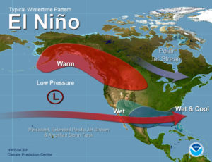
This image shows a classic “El Nino” year. Characterized by a strong shot of cold air into the north east and a burst of drier, somewhat less cold air into the north west (bear in mind what I have just discussed). But what you are about to discover is that this year is not a normal El Nino as such.

This year is something known as a Modoki El Nino. Now the “El Nino Region” can be split up into 4 parts, Nino 1+2, Nino 3, Nino3.4 and Nino 4. They all represent different sections of the Pacific Ocean. Nino 1+2 represents the area immediately off the coast of Peru in the Pacific and Nino 3 further west by a few hundred miles, and so on so forth. This year there are signals for, during the winter time, a “central based El Nino”, during which there is a bias in the warmth that is contained in the El Nino event to stagger or collect further west than expected. Usually the warm waters during an El Nino are fairly evenly distributed across the Pacific Ocean. This year a more “central” distribution of El Nino is predicted. This could have some fairly interesting impacts.
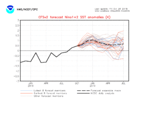
Here you can see the predicted temperatures in the “Nino 1+2” region, which is located immediately off the coast of Peru.

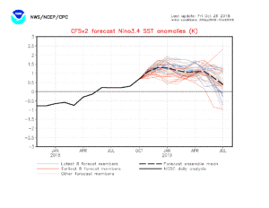
Here you can see the predicted temperatures for the “Nino 3.4” regions, which are based in the “central” region of the Pacific Ocean.

Those temperatures in the central region are predicted to be about 0.3C higher than the eastern region near the coast of Peru.
In a normal El Nino the highest anomalies would be fairly evenly distributed throughout the 4 El Nino regions or even congregate slightly towards the coast of Peru as seen during 2015 and 1997, however this year El Nino is slightly more central based. The same thing occurred in the winter of 2014-15. This is significant because it may weaken the strength of the blocking area of high pressure centered over the north west of the US and Canada, allowing for still a slightly milder and drier season but on the whole more of a leeway in terms of allowing lower pressure to form over central states and to push Arctic plunges in the central U.S. Of course El Nino also has the impact of increasing the strength of the polar jet into the north east of Canada and the U.S. interacting with the potential for snow storms and blizzards here.
